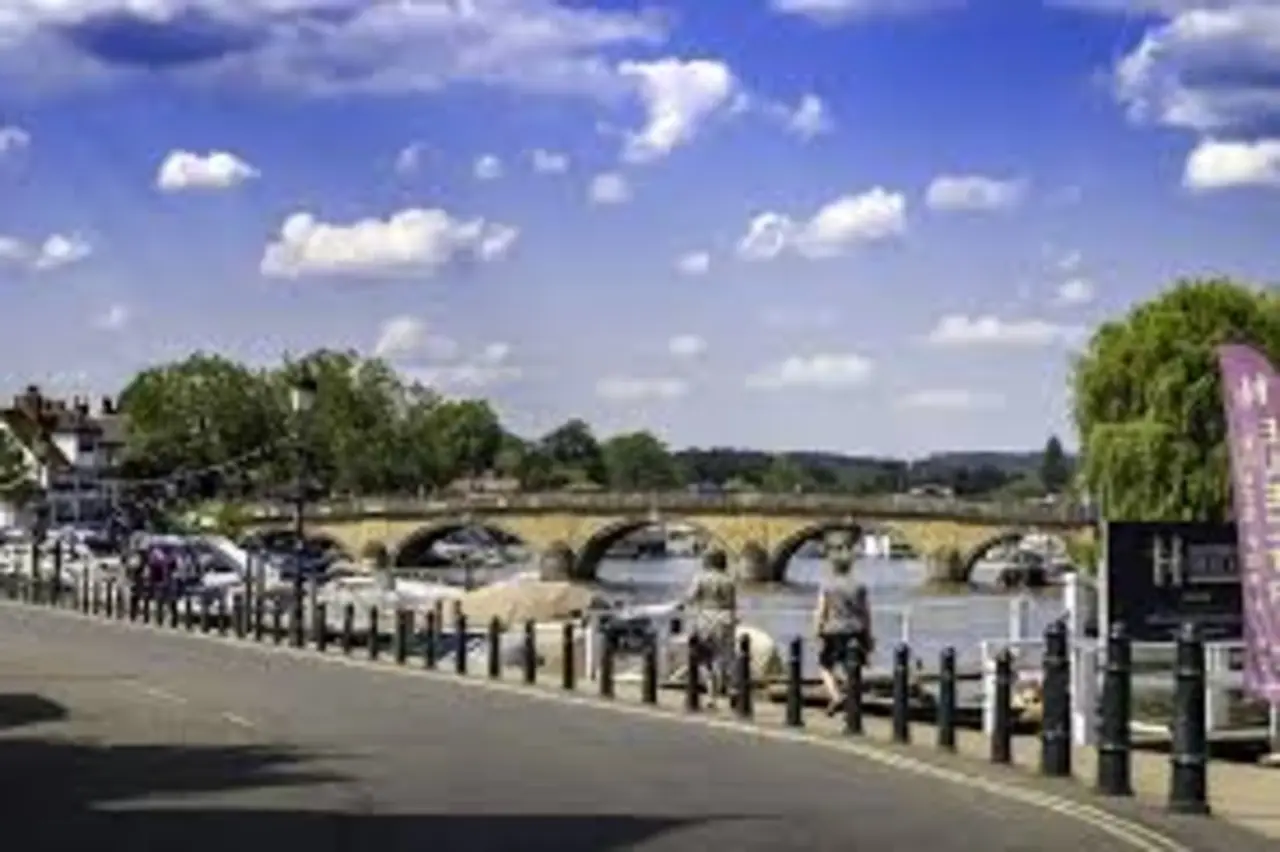
At first glance, the river at Henley can look untroubled: a broad, slow sweep of the Thames, houseboats nudging their moorings, swans moving with practised entitlement. Then the traffic arrives. A line of cars inches towards the water. Cyclists thread through. Pedestrians pause at the parapet to watch a crew training upstream, blades catching the light in quick, disciplined flashes. The whole scene is held together by a single structure that is at once ordinary and symbolic: Henley on Thames Bridge.
To residents, it is simply the way across. To rowers, it is a marker on one of the best-known stretches of racing water in the world. To engineers and conservationists, it is a working piece of eighteenth-century infrastructure that must carry modern loads without losing what makes it special. And to anyone trying to understand Henley itself, the bridge is a good place to start, because it explains why the town sits where it does, how it grew, and what pressures it lives with now.
This is not a bridge you can treat as a backdrop. It is a boundary and a meeting point: between Oxfordshire and Berkshire, between town and village, between the commercial history of a river port and the contemporary reality of commuter routes and weekend crowds. The story of Henley on Thames Bridge is the story of a river crossing that has had to keep adapting, quietly, to the changing needs of the people who use it.
A crossing that shapes the map: where the bridge sits and what it connects
Henley-on-Thames occupies a strategic bend in the river, at a point where the Thames is navigable, broad enough to carry traffic, and close to routes that run east–west across the Chiltern fringe. That combination helped the town develop as a market centre and river port, with goods moving by water long before roads were reliable.
Henley on Thames Bridge links the town centre to the south bank at Remenham, in Berkshire, a smaller settlement with its own distinct identity and a different landscape character: more open river meadows, estate land, and the approach towards the Hambleden Valley. The county boundary matters, not just in administrative terms but in the way it divides responsibilities for roads, planning and sometimes the simple practicalities of maintenance and traffic management.
The bridge also acts as a visual anchor. Stand on the north bank and you can read the town from it: the compact cluster of buildings behind, the church tower, the waterfront, the sense of a place that has long had to orient itself to the Thames. The view the other way is just as telling. Upstream, the river narrows and curves through wooded reaches that have become synonymous with rowing. Downstream, it opens towards Wargrave and Reading, with a different rhythm of traffic and tourism.
Because it is the most direct crossing in the immediate area, Henley on Thames Bridge inevitably concentrates movement. That is true on summer Saturdays when day-trippers arrive, and it is true on weekday mornings when commuters use the route to reach rail connections, schools, offices and the motorway network beyond. The bridge is not merely in Henley; it helps to determine how Henley functions.
The earlier bridges: timber, tolls and the long memory of the Thames
The stone structure people recognise today is not the first bridge at Henley. Like many historic river towns, Henley’s relationship with the Thames began with the practical question of how to get across safely and regularly. For centuries, that meant a mixture of ferries, fords in favourable conditions, and early bridge structures that were often built of timber and vulnerable to flood, decay and the occasional catastrophe of ice or collision.
Medieval and early modern bridges were frequently a matter of local politics and private finance. A bridge could be funded by a wealthy patron, sanctioned through royal or ecclesiastical authority, or maintained through tolls. Control of a crossing was control of trade. If you could reliably get goods over the river at Henley, you could move produce from the Chilterns and the Thames Valley to markets further afield. The town’s fairs and markets, and its later reputation as a river port for grain, timber and other goods, are inseparable from the idea that the crossing must work.
These early bridges were not romantic structures. They were practical, often narrow, built for pedestrians, carts and animals, and they required constant repair. The Thames is not a gentle stream; it is a managed river with powerful flows in flood conditions, and a long history of reshaping its own banks. Timber piles rot. Decks warp. Flood debris catches on supports and increases pressure. Even where communities were committed to maintaining a bridge, money and expertise were not always sufficient.
By the eighteenth century, with growing traffic and changing standards of infrastructure, the case for a more durable crossing became harder to ignore. The old bridge was increasingly inadequate for the demands of the time, and the idea of a new, permanent stone bridge began to take hold. What would eventually become Henley on Thames Bridge was born out of that moment: a period when Britain, emerging into an era of turnpikes, canals and early industrial expansion, started to treat transport infrastructure as a national priority rather than a patchwork of local improvisations.
Building the present bridge: eighteenth-century ambition in stone
The current Henley on Thames Bridge dates from the late eighteenth century, the product of a deliberate decision to replace the older structure with something built to last. Its design is typically Georgian in spirit: orderly, balanced, and confident in the language of classical proportions. It is neither flamboyant nor purely utilitarian. It was made to be seen as well as used.
The bridge is generally associated with the architect William Hayward, and it opened in the 1780s. It is built as a multi-arch stone bridge, with a broad central span and smaller flanking arches, allowing the river to pass through without creating a single pinch point. The parapets and balustrades have a restrained elegance, and the overall effect is of a civic work intended to represent the town as much as to serve it.
Such a project required more than design flair. It required funding, legal authority, and the organisation of skilled labour. Stone bridges of this kind were major investments. Money had to be raised, often with the help of Acts of Parliament or local trust arrangements, and tolls were commonly used to recoup costs over time. The introduction of tolls could be controversial, but in many places it was the only workable method of financing construction and ensuring ongoing maintenance.
The bridge also had to accommodate river navigation. The Thames at Henley has long been a working waterway, with barges and boats needing adequate clearance and predictable flow. The arrangement of arches and the height of the roadway were not aesthetic choices alone; they were engineering responses to the realities of river traffic and floodwater.
If the eighteenth-century builders had one advantage, it was the accumulated knowledge of bridge-building across Britain. If they had one disadvantage, it was the unpredictability of the river itself. Building piers in flowing water is always a negotiation with conditions you cannot fully control: water levels, riverbed composition, and the constant risk that a flood will undo months of work.
Over time, the bridge has needed repair and adaptation, but its fundamental form has remained recognisably the same. That continuity is part of its significance. In an age when many crossings are widened, rebuilt, or replaced within a century, Henley on Thames Bridge is a reminder that careful design and solid materials can create infrastructure with a long public life.
How the bridge works: arches, foundations and the problem of a changing river
It is easy to think of an old bridge as a static object: stone on stone, heavy and settled. In reality, Henley on Thames Bridge is part of a dynamic system. The river pushes against it. The weather tests it. Vehicles impose repeated loading on the structure in patterns that eighteenth-century designers could not have anticipated.
The arches are central to its strength. An arch bridge carries weight by directing forces outwards and down into the piers and abutments. When properly built and maintained, that arrangement can be remarkably durable. But the durability depends on the condition of masonry, the stability of foundations, and the management of water flow around the piers.
A riverbed is not fixed. Scour, the process by which fast-moving water erodes material around piers, can undermine foundations over time. Floods can accelerate this, particularly when debris accumulates against a pier and increases turbulence. Even small changes in flow patterns can matter. Maintaining an old bridge is therefore not only about visible stonework; it involves inspections, sometimes underwater surveys, and careful decisions about when and how to intervene.
There is also the matter of the bridge’s surface and parapets. The fabric that pedestrians touch and vehicles roll across must cope with wear, frost, road salt, and the gradual settling that comes with age. For heritage structures, maintenance becomes a balancing act: repairs should protect the bridge’s historical character while ensuring safety and functionality. Modern materials can be tempting because they are efficient, but they can behave differently from historic stone and mortar, sometimes trapping moisture or causing unintended damage.
Listing status adds another layer. Henley Bridge is a protected historic structure, and that protection is not mere bureaucracy. It reflects an understanding that a bridge is part of the town’s architectural heritage, as significant as a church or a market hall. Repairs and alterations may require careful consent processes, with input from conservation officers and, in some cases, national heritage bodies.
This can frustrate users when repairs cause disruption, but it is a necessary discipline. Without it, historic infrastructure is often “improved” in ways that strip out what makes it valuable, leaving a sanitised, generic object. The point of conservation is not to freeze a bridge in time; it is to ensure that changes are thoughtful and reversible where possible, and that the original structure remains legible.
The regatta relationship: why rowing and the bridge are inseparable
For many people around the world, the name Henley conjures rowing before it conjures a town. That is not accidental. The Thames at Henley is one of the most famous competitive rowing venues on earth, and the bridge sits right at the heart of that identity.
Henley Royal Regatta, held annually, uses a course upstream, with the finish in the town and the bridge acting as a defining landmark. The structure becomes a viewing point, a meeting place, and a practical constraint, because large crowds and event infrastructure must be managed in a space that still needs to function as part of a working town.
The bridge’s relationship with the regatta is not merely picturesque. It influences how the event operates: crowd control on and around the crossing, coordination with river authorities, and the choreography of movement between the town centre and the enclosures on the Berkshire side. Even outside regatta week, rowing shapes the use of the river at Henley. Training crews, coaching launches and leisure boaters share a stretch of water that can become busy, and the bridge is a fixed point everyone must navigate around, visually and physically.
There is also the less romantic side. Major events bring pressure on local services: policing, waste management, transport, and the management of public space. Residents who enjoy the atmosphere can still find it disruptive. Those who rely on the crossing for everyday journeys may face delays or diversions. The bridge becomes, temporarily, a piece of event infrastructure as much as a highway.
The fact that the town and the regatta coexist year after year is a testament to organisation and to a degree of local tolerance. But it is not effortless. It requires planning that respects both the cultural significance of the event and the simple reality that a bridge is, first and foremost, a way of getting people across a river.
Daily life on the bridge: traffic, walking, cycling and the struggle for space
Most days, Henley on Thames Bridge is not a set piece. It is a working part of the road network, and it bears the consequences of modern travel habits. The road is relatively narrow by current standards, and the pavements, while adequate for normal foot traffic, can feel tight when flows are heavy.
For motorists, the bridge can be a bottleneck. Henley’s attractive town centre streets were not designed for large volumes of contemporary traffic, and the crossing concentrates vehicles into a limited space. Junctions on either side of the river, parking patterns, and the pull of nearby amenities can all contribute to congestion. In summer, this is amplified by visitors; in winter, by darker evenings and a more cautious driving style.
For pedestrians, the bridge is both route and viewpoint. People stop to look at the river, and that pauses the flow. When the bridge is crowded, a few stationary onlookers can force others into awkward squeezes. The pleasure of pausing to watch boats has to be balanced with the basic need to keep people moving safely.
Cyclists sit somewhere in between. On paper, the bridge is a straightforward crossing, but in practice it can be uncomfortable at peak times, particularly for less confident riders. Close passing by vehicles, limited width, and the need to negotiate around pedestrians at the entrances all create a sense of friction. What looks like a simple piece of infrastructure becomes, in use, a place where competing needs meet.
Accessibility is part of the conversation too. Historic bridges rarely conform neatly to modern expectations around kerbs, gradients and the ease of navigation for wheelchairs and pushchairs. Adjustments can be made, but each one must be considered within a conservation framework. The goal is not to pretend the past can be rewritten, but to ensure that the bridge is as inclusive as possible without damaging the structure’s integrity.
Noise and air quality are often overlooked. A bridge in a town centre becomes a place where traffic noise carries over water and echoes off masonry. When cars queue, emissions concentrate. Residents and shopkeepers nearby experience this not as an abstract environmental issue but as a daily sensory reality. Managing traffic flow, encouraging alternative travel modes, and limiting unnecessary through-traffic are therefore not only transport issues; they are quality-of-life decisions.
Flooding, river management and the bridge’s role in resilience
The Thames is regulated by locks and weirs, and managed by agencies with responsibilities for navigation and flood risk. Even so, flooding remains part of the river’s character. In the Thames Valley, periods of sustained rain can swell tributaries and saturate ground, sending water levels up and putting pressure on towns along the banks.
A bridge can influence flood behaviour in subtle ways. Piers and arches affect flow patterns. Debris can catch. High water can reduce clearance for boats and create dangerous conditions downstream. In extreme events, approaches to the bridge may flood before the bridge itself becomes structurally threatened, creating disruption even when the masonry remains sound.
Henley’s riverside setting brings a certain vulnerability. Low-lying areas near the waterfront can be affected by high river levels, and the town has to coordinate responses that involve local councils, emergency planning, and the Environment Agency’s wider management of the Thames. The bridge is central to those responses because it connects key routes and because any closure or restriction has knock-on effects across the local network.
Climate change adds complexity. Warmer air holds more moisture, and rainfall patterns are becoming less predictable. The Thames has seen major flood events in recent decades, and resilience planning increasingly has to account for scenarios that were once considered rare. For an eighteenth-century bridge, this means more attention to inspection regimes, to the condition of masonry joints, and to the management of scour risk.
It also means thinking about the approaches: drainage on the roads leading to the bridge, the protection of nearby properties, and the maintenance of riverbanks. Resilience is not a single project. It is an accumulation of decisions, from how quickly debris is cleared after storms to how traffic is rerouted when riverside roads are inundated.
Conservation in practice: repairs, politics and what the public expects
Because Henley on Thames Bridge is both historic and heavily used, any intervention attracts attention. People notice when surfaces change, when scaffold goes up, when temporary lights appear, or when repairs disrupt routines. They also notice when nothing seems to happen and small problems linger: loose stones, damaged kerbs, worn paving, or the visual untidiness that can come with patchwork maintenance.
The politics of conservation are rarely straightforward. Local authorities operate under budget constraints, and maintenance competes with other priorities: schools, social care, road repairs elsewhere. Heritage protections can increase the cost and complexity of work, but they also prevent false economies that would harm the structure in the long term.
Public expectations can pull in opposite directions. There is an understandable desire for minimal disruption, but also a demand for high-quality repairs. There is affection for the bridge’s historic character, but also pressure to modernise, to improve safety, or to provide better accommodation for cycling. Each of those goals can be legitimate, but they do not always align.
Behind the scenes, a great deal depends on expertise: structural engineers who understand masonry bridges, conservation specialists who know historic materials, and project managers who can plan works around river conditions and seasonal constraints. A repair that looks simple on the surface may require careful sequencing, because working over water raises safety issues and demands different scaffolding and access solutions.
There is also the question of who is responsible. Bridges can fall under different jurisdictions depending on their classification, their history, and local government arrangements. On a boundary crossing like Henley’s, coordination is essential. The public may simply want “the council” to fix things, but the reality can involve multiple bodies, consultation requirements and legal responsibilities that slow decision-making.
If that sounds like a recipe for frustration, it can be. Yet the alternative is worse: ad hoc changes and poorly specified repairs that shorten the life of the structure. The bridge has lasted because it has, broadly, been cared for. The challenge now is to maintain that care in an era of intense use and constrained public spending.
The bridge in the town’s story: commerce, identity and the working Thames
It is tempting to treat Henley’s riverside as a leisure zone, defined by rowing, pleasure boating and scenic walks. Historically, the Thames at Henley was also a commercial route. Barges carried goods, and the town’s prosperity was linked to the river as a transport corridor. The bridge was part of that economy, enabling movement between the river, the market, and the land routes beyond.
Even as commercial river traffic declined and road and rail networks took precedence, the bridge remained economically important. It influences footfall in the town centre, links businesses on either side, and shapes how visitors move. When the bridge is congested or closed for works, it is not only an inconvenience; it has consequences for trade and for the town’s ability to function.
Identity is harder to quantify but just as real. Henley’s image, in photographs and media coverage, repeatedly returns to the bridge and the water beside it. The stone arches and parapets are part of the town’s visual signature. This can create a sense of pride, but it can also put pressure on the town to maintain an appearance that matches public expectations, even when local needs are more prosaic.
The bridge, in other words, sits at the intersection of heritage and practicality. It is a symbol, but it is also tarmac, drainage, stone joints, routine inspections and the constant negotiation of limited space. That dual role is why debates about the bridge can become heated: people are arguing not only about transport, but about what Henley is and who it is for.
Visiting and using the bridge: what to notice, and how to move through it
Many people encounter Henley on Thames Bridge casually, perhaps on a walk along the Thames Path or on their way into town. It can reward a slower look, provided that looking does not obstruct others. The stonework shows the deliberate symmetry of Georgian civic design. The relationship between the arches and the waterline is different in winter and summer, and the river’s behaviour under the bridge changes with flow and wind.
If you approach from the town side, the bridge is experienced as an extension of the street network, with shops and riverside spaces close by. From the Berkshire side, it often feels more like an arrival into Henley, particularly during events when the towpath and meadows are busy. Either way, the bridge is best understood not as a standalone object but as a connector between landscapes: built townscape on one bank, more open riverside on the other.
River users see it differently again. For boaters, the arches frame the view and demand attention to navigation, particularly when the river is busy. For rowers, the bridge is a boundary of sorts, a point that signals the end of a training piece or the climax of a race. For anglers and walkers, it is a place where the river can be watched at close quarters.
None of this requires grand gestures. The bridge’s interest lies in its ordinary complexity: how many different lives it accommodates within a limited span, and how the river remains the constant that makes those lives intersect.
Conclusion: a working structure with a public future
Henley on Thames Bridge endures because it is useful. It carries people, vehicles and local life across a major river at a point where a crossing has been needed for centuries. Its stone form, rooted in eighteenth-century confidence, has proved robust enough to handle modern pressures, but not without careful maintenance and periodic debate.
The bridge’s importance is not only architectural or historical, though it is both. It is practical infrastructure in a place where space is limited, demand is high, and the river itself is changing in ways that require new thinking about resilience. The decisions made about how the bridge is cared for, how traffic is managed, and how different users are balanced will shape Henley’s daily experience more than any slogan about heritage ever could.
To stand on Henley on Thames Bridge is to see the town’s past and present pressed into the same frame: the working river, the ceremonial rowing course, the commuter traffic, the slow walkers, the stone that holds it all together. It is not a museum piece. It is, still, a crossing.