To people outside the North West, “Liverpool” can sound like a single, self-contained city. In reality, the Liverpool City Region is a working geography that stretches from coastal resorts and commuter villages to industrial riverfronts and post-war new towns. It is tied together by the Mersey, by rail and road routes that funnel into the city centre, and by a shared labour market that has long ignored municipal borders.
For UK readers trying to make sense of the areas in Liverpool City Region, the most helpful starting point is that it is both a place and a system. It is a place in the everyday sense: somewhere you can recognise on a map, with distinct accents, football loyalties, shopping streets and parks. But it is also a system of local government and public services, increasingly shaped by devolution, transport planning and economic strategy. Understanding it means holding both views at once: the fine-grain texture of neighbourhoods and the larger pattern of boroughs that collaborate and sometimes compete.
What follows is a grounded guide to the main areas in Liverpool City Region, how they differ, and how they connect.
What the Liverpool City Region covers, and why it matters
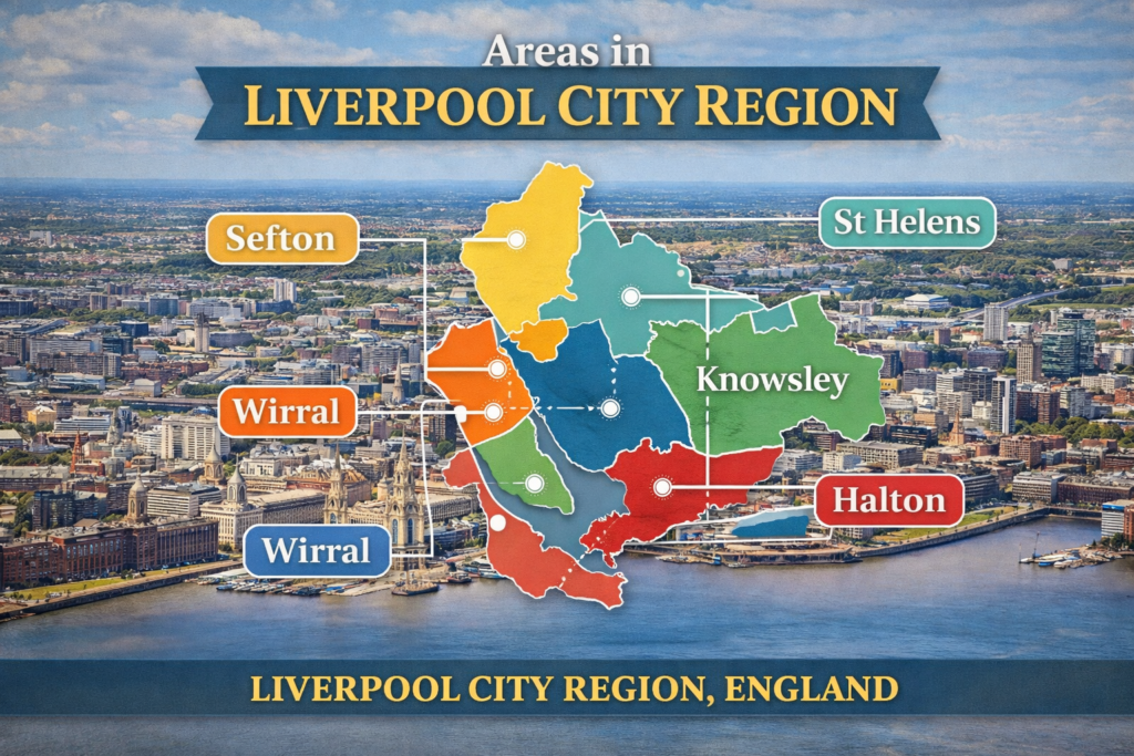
The Liverpool City Region Combined Authority brings together six local authority areas: Liverpool, Sefton, Wirral, Knowsley, St Helens and Halton. That boundary is not arbitrary. It reflects commuting flows, shared infrastructure and an economy historically organised around the port, manufacturing and trade along the Mersey corridor.
The City Region is not the same as Merseyside, though there is substantial overlap. Halton, for example, sits in Cheshire but is part of the City Region. Some neighbouring towns with strong links to Liverpool, such as parts of West Lancashire, fall outside the Combined Authority area. For residents, these distinctions can influence which buses and rail tickets apply, which adult education programmes are funded, and which regeneration priorities are pursued.
The phrase areas in Liverpool City Region is often used by people comparing places to live, looking for schools and housing, or simply trying to understand why a journey that feels “local” crosses multiple councils. It is also increasingly relevant for public policy: transport investment, skills funding and strategic planning are shaped at City Region level even when delivery happens in individual boroughs.
Liverpool: the core city, with neighbourhoods that feel like separate towns
Liverpool remains the gravitational centre. Its city centre is the region’s main hub for offices, universities, hospitals, major retail and cultural venues. Yet Liverpool is also a city of strong local identities, where districts have their own history and pace.
Around the commercial core, neighbourhood change is visible in the built environment. The Georgian Quarter, with its terraces and cultural institutions, sits close to the university precincts, where student housing and academic expansion have transformed parts of the inner city. To the south, the Ropewalks area has developed a dense mix of apartments, bars and independent venues, while the Baltic Triangle has moved from warehouses to creative industries, small manufacturing and events space. These shifts bring jobs and footfall, but also the familiar tensions around affordability, noise, short-term lets and what “regeneration” means in practice.
North Liverpool carries some of the city’s sharpest contrasts. Everton and parts of Kirkdale and Anfield have faced long-running issues linked to poverty, health inequality and historic clearances, alongside determined community organising and new housing development. The Anfield area, shaped by football stadium expansion and matchday economics, is an example of how a single institution can affect housing demand, local business patterns and transport pressure.
South Liverpool contains many of the city’s more suburban districts, with a different housing mix and often a different relationship to the city centre. Aigburth and Allerton are known for Victorian and early 20th-century housing stock, access to green space such as Sefton Park, and strong local high streets. Woolton and parts of Mossley Hill show how village-like centres can persist within a city boundary, while Speke, at the city’s edge, has been shaped by industrial land, the airport nearby and post-war planning.
Liverpool’s waterfront is more than a postcard. The port and logistics economy remains significant, while the visitor economy is concentrated in the central docks and cultural quarter. The city’s challenge, as ever, is to convert central growth into wider opportunity across its districts, particularly where employment barriers and health outcomes remain stubborn.
Sefton: coastline, commuter corridors and a borough of contrasts
To the north of Liverpool, Sefton runs from dense urban neighbourhoods near the docks to some of the country’s most celebrated coastal landscapes. This variety is central to understanding the areas in Liverpool City Region: Sefton’s places can feel as if they belong to different regions altogether.
Southport, at the northern end, is a seaside town with a distinctive Victorian layout, a long promenade and a visitor economy that mixes day trips with conferences and events. It has pockets of affluence and areas that face deprivation, like many coastal towns, and it sits at a physical distance from Liverpool that affects transport choices and commuting patterns.
Formby and its surrounding villages are closely associated with dunes, pinewoods and the National Trust coastline, and with a more affluent commuter profile. The presence of protected landscapes shapes planning decisions and limits large-scale development, which in turn influences housing supply and prices.
Crosby, including Waterloo and Blundellsands, sits closer to Liverpool and has strong rail links. Its appeal is often tied to schools, a walkable high street and the beach, while also being close enough to the city for day-to-day commuting. Further inland, Maghull and surrounding areas illustrate the borough’s suburban character, with estates and newer developments built around rail stations and road access.
Bootle, nearer the docks, has a different history again: more industrial, more closely tied to port-related employment and logistics, and affected by the decline of traditional industries. Regeneration projects and changes to retail have reshaped the town centre, but the underlying story is about how a working port economy adapts to automation, global trade patterns and modern distribution.
Wirral: a peninsula with two faces, and many in between
Across the Mersey, Wirral is a peninsula of sharp internal contrasts. It contains post-industrial urban centres, prosperous coastal suburbs and rural fringes, and its links to Liverpool are both physical, via the tunnels and rail lines, and cultural, via shared workplaces and family ties.
Birkenhead is the largest urban centre and has a deep industrial and maritime history. Parts of Birkenhead have seen substantial regeneration efforts, from housing to docks redevelopment, and it continues to be a focus for debates about investment, town centre renewal and what kind of employment base can replace older manufacturing. The town’s parks and civic buildings also speak to the Victorian ambition that once powered it.
To the north-east, Wallasey and New Brighton are shaped by their coastal position. New Brighton has had repeated cycles of decline and reinvention; it remains a place where public realm improvements, arts venues and leisure development are often discussed alongside concerns about seasonal trade and local spending power.
West Wirral, including Hoylake, West Kirby and Heswall, is commonly perceived as more affluent, with a housing stock that includes larger suburban properties and areas with strong school reputations. The Dee Estuary and coastal paths bring a different rhythm of life, as do sailing and outdoor activities, and the area’s planning disputes often centre on balancing development with green belt and habitat protections.
Further south, Neston and surrounding villages sit close to the Cheshire boundary and have their own semi-rural character. For many residents, Wirral is not simply “across the water” from Liverpool, but a place with internal geographies that can be as decisive as the river itself.
Knowsley: historic market roots, post-war estates and a major logistics corridor
Knowsley is sometimes reduced in public discussion to deprivation statistics, which misses the complexity of its built environment and its economic role. The borough includes towns and districts such as Huyton, Kirkby, Prescot and Whiston, each with distinct histories.
Huyton has a town centre that has been the subject of redevelopment and reconfiguration, and it functions as a transport node for commuters travelling into Liverpool and beyond. Kirkby, built up significantly in the post-war period, has a history tied to overspill housing and industrial change; more recent years have brought retail development and ongoing debates about town centre identity and local employment.
Prescot, historically a small market town, has gained renewed attention for cultural investment, including theatre, and for its place on key rail and road routes. Whiston, meanwhile, is often associated with health services due to the hospital, and with suburban neighbourhoods that sit close to major roads.
Knowsley is also crucial to the City Region’s logistics economy. Industrial estates and distribution centres benefit from proximity to the M62 and regional road networks. That brings jobs, but it also raises questions about job quality, automation, land use, and the environmental impact of freight traffic. As with other areas in Liverpool City Region, the story is not a simple one of decline or growth, but of transition.
St Helens: reinventing a post-industrial town in the commuter belt
St Helens sits to the east of Liverpool, historically famous for glassmaking and heavy industry. The town centre and surrounding districts continue to adapt to the decline of traditional manufacturing and the changing nature of retail. Like many UK towns, it faces the challenge of keeping a town centre relevant when shopping habits move online and leisure expectations change.
Yet St Helens is not solely a story of loss. Its transport position between Liverpool and Manchester shapes housing demand, commuting patterns and employer interest. Newton-le-Willows and Earlestown have their own identities within the borough, with rail connections that make them attractive to commuters, while areas such as Rainford and the borough’s rural edges offer a different, more village-like feel.
St Helens also holds strong cultural anchors, from rugby league to local heritage, and its regeneration priorities often focus on skills, health outcomes and creating a more diverse employment base. In the wider map of areas in Liverpool City Region, it is a reminder that the City Region is not just the river corridor but also the eastern towns that connect two major cities.
Halton: Widnes and Runcorn, and the importance of crossing points
Halton is sometimes overlooked in casual descriptions of the Liverpool City Region, partly because it lies south of the Mersey in Cheshire and partly because its identity is shaped by river crossings and industry rather than by tourism or a single city centre.
Widnes has a long association with chemical and industrial employment. Over time, parts of its riverfront and town centre have been reshaped, but its economic story still reflects the wider challenge of transitioning from heavy industry to a mixed economy with modern manufacturing, services and logistics.
Runcorn is strongly defined by post-war planning and its distinctive road network, as well as by its position on the Mersey. The Mersey Gateway Bridge and the older Silver Jubilee Bridge are not just pieces of infrastructure; they influence commuting times, business location decisions and the daily geography of residents travelling to jobs across the region. Runcorn’s links by rail and road also place it within reach of Liverpool, Chester and Manchester, reinforcing the City Region’s wider connectivity.
For anyone assessing areas in Liverpool City Region, Halton illustrates how the region’s southern edge is both separate and deeply connected: a place with its own industrial heritage, yet integrated through transport and labour markets.
How transport stitches the City Region together
It is impossible to understand the areas in Liverpool City Region without understanding transport. The Merseyrail network is central for many communities, particularly along the Northern and Wirral Lines, shaping residential choices and local economies around stations. Places such as Formby, Crosby, Birkenhead and West Kirby have daily rhythms that follow train timetables as much as local opening hours.
Beyond rail, the road network is decisive. The M62 connects Liverpool to the wider North, while the M57 and key A-roads funnel traffic between outer boroughs and the city. The Mersey tunnels provide essential cross-river links, and any disruption quickly becomes a regional problem, not merely a Liverpool one.
Liverpool John Lennon Airport, near Speke, influences employment and the travel economy and has knock-on effects for nearby districts, from traffic patterns to land use planning. Meanwhile, bus services and active travel routes remain crucial for those who do not drive, and they are often where the gap between strategic ambition and lived reality is most keenly felt. Reliability, affordability and service coverage can differ markedly between neighbourhoods, shaping access to work, education and healthcare.
Transport policy has therefore become a core feature of devolution debates, because better connections are often presented as a route to shared prosperity. But investment choices also raise questions: who benefits first, which town centres gain footfall, and how to balance road building with climate commitments.
Housing, services and the lived experience of place
People rarely choose between boroughs in the abstract. They choose between street types, school catchments, access to green space, commuting time and the feel of a high street on a weekday evening. In the Liverpool City Region, the housing stock ranges from dense inner-city terraces and tower blocks to interwar semis, post-war estates and newer suburban developments. That variety reflects the region’s layered history: port growth, industrialisation, wartime damage, slum clearance, overspill estates and more recent cycles of renewal.
Public services also vary by area, shaped by council budgets, historical infrastructure and demographic pressures. Proximity to major hospitals, for instance, can be an everyday factor for families, while access to further education and apprenticeships can influence young people’s choices. Cultural amenities cluster in Liverpool city centre, but local libraries, leisure centres, parks and community venues are often what define quality of life.
Equally important are the less measurable factors: whether a place feels safe, whether neighbours know each other, whether a town centre is busy or hollowed out. Across the areas in Liverpool City Region, there are communities that feel remarkably stable and others still dealing with the after-effects of economic shocks from decades ago.
Identity, inequality and what comes next
The Liverpool City Region’s identity is strong, but it is not uniform. Liverpool’s global cultural image can overshadow the surrounding boroughs, yet those boroughs are not satellites in the passive sense; they have their own histories, loyalties and local pride. The City Region framework attempts to reflect interdependence without erasing difference.
The hardest truth is that inequality remains embedded across the region. Some neighbourhoods face multi-generational disadvantages linked to health, employment and housing conditions, while others benefit from inherited wealth, stronger property markets and more stable local economies. These patterns often sit uncomfortably close together, sometimes within the same borough and occasionally within the same postcode district.
At the same time, there are reasons to take the region seriously as a place of renewal. Its universities, hospitals, port infrastructure, advanced manufacturing potential and cultural economy provide foundations that many areas would envy. The task is to ensure that growth is not confined to a few central zones or headline projects, but reaches the estates, town centres and coastal communities where daily life is most pressured.
Understanding the areas in Liverpool City Region, then, is not about memorising boundaries. It is about seeing how a major city, a set of boroughs and a shared transport and jobs market interact. The region is a mosaic: coastal dunes and docklands, peninsula suburbs and former industrial towns, busy student streets and quiet villages. Its future will depend on whether that mosaic can be connected more fairly, without flattening the character that makes each part distinct.