On the map, Fountainbridge sits close to Edinburgh’s centre, yet for decades it felt like somewhere you passed through rather than lingered in. Walk west from Lothian Road and the theatres of the city centre, cross the busy junctions at Tollcross, and the streets begin to open out. The skyline shifts too. Instead of spires and Georgian terraces you see modern apartment blocks, office buildings, remnants of older brick industry, and the unexpected line of the Union Canal cutting through it all. This is Fountainbridge: neither postcard Old Town nor suburban fringe, but a district that has repeatedly reinvented itself.
To understand Fountainbridge Edinburgh Scotland as it is today, you need to hold two seemingly contradictory truths in mind. First, it is an ancient urban edge, historically tied to the city’s growth and to the hard, physical industries that once drove Edinburgh’s economy. Second, it is one of the capital’s most visible regeneration stories, where former works sites have been turned into housing, leisure and commercial space at speed, sometimes with genuine civic ambition and sometimes with a developer’s logic that residents are left to live with.
Fountainbridge is not a museum piece. It is a living neighbourhood where people work, study, rent, buy, commute, raise children and argue about planning applications. Its canalside paths are used by cyclists and dog walkers; its new flats are marketed as central living; its older tenements still carry the marks of an earlier, tougher Edinburgh. The question that hangs over the area is not simply what it used to be, but what kind of place it is becoming.
Where Fountainbridge sits, and why its boundaries are blurred
Ask five people where Fountainbridge begins and ends and you may receive five different answers. That is partly because the district has no single, universally agreed boundary, and partly because it blends into neighbouring areas with their own strong identities: Tollcross to the east, Dalry to the west, Polwarth and Merchiston to the south, Haymarket and the West End to the north.
In practical terms, Fountainbridge Edinburgh Scotland is often understood as the area around Fountainbridge itself and Dundee Street, stretching towards Grove Street and the canal at Lochrin Basin. The A700 corridor and Lothian Road funnel traffic nearby; the neighbourhood is close enough to the city centre to feel central, yet it also contains big plots of land that, until recently, were industrial or underused. Those large sites are one reason Fountainbridge has changed so quickly compared with districts built almost entirely from tenements and tight street grids.
What anchors the area is the Union Canal. While many Edinburgh districts are defined by hills and views, Fountainbridge is defined by a straight line of water that moves at its own pace through the city. That canal is both historical infrastructure and present-day amenity, and it is impossible to tell the story of Fountainbridge without it.
The making of a working district: breweries, rubber and the heavy city
For much of the nineteenth and twentieth centuries, Fountainbridge was the kind of place that underpinned Edinburgh without being celebrated by it. This was a working district, shaped by the city’s industrial expansion and by the canal and rail links that made large-scale production feasible.
The best-known industrial presence was brewing. The Fountain Brewery, closely associated with McEwan’s and later with larger corporate ownership, became a landmark in its own right: a vast complex that dominated the area’s economy and skyline. Edinburgh’s brewing history is often told through the more picturesque closes and vaults of the Old Town, but brewing on an industrial scale required space, transport connections and access to water. Fountainbridge had those conditions, and the brewery grew accordingly.
Alongside brewing sat other industries, including rubber manufacture. The North British Rubber Company, to name one of the most significant, produced everything from footwear to industrial goods and was part of the dense cluster of manufacturing that once existed across this side of the city. These were not light, genteel trades. They meant shift work, noise, soot, lorries, and the smell of production that clung to streets and clothing. In an era when employment was often local, the proximity of such works shaped daily life: the rhythms of the shift change, the pubs and shops that served workers, the housing demand and the social networks.
It is important not to romanticise this past. Industrial Fountainbridge offered wages and community, but it also brought pollution and hard labour. Yet it did give the district a distinct identity. Fountainbridge was not simply near Edinburgh; it was an engine room of Edinburgh.
The Union Canal and Lochrin Basin: from freight corridor to urban waterfront
The Union Canal opened in the early nineteenth century to connect Edinburgh to the Forth and Clyde Canal, creating a waterway link to the west. In the age before rail dominated, canals were strategic infrastructure, designed to move heavy goods more cheaply than road transport. By the time many people now think of canals as leisure spaces, the Union Canal had already lived several lives: commercial artery, industrial backdrop, then something closer to neglected urban edge.
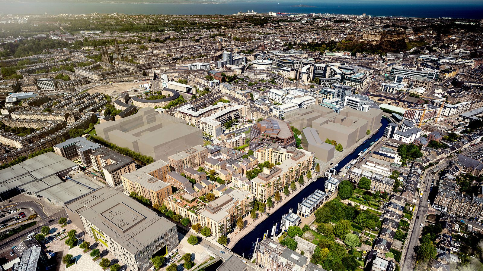
In Fountainbridge, the canal’s presence is particularly striking because it emerges from behind buildings and suddenly becomes the organising feature of the landscape. Lochrin Basin, close to the heart of the modern redevelopment, is a key point. Historically it was part of the canal’s working geography; today it functions as a kind of urban waterside square, framed by new buildings and crossed by footbridges.
The transition from freight corridor to leisure and active travel route has been one of the most profound shifts in Fountainbridge Edinburgh Scotland. A canal that once carried goods to and from factories now carries joggers, cyclists, paddleboarders and slow-moving narrowboats. That shift is not merely aesthetic. It has changed how people move through the area, how the district is marketed, and how residents experience their own neighbourhood.
There is also a subtler change: the canal has become a mental map line. It is used as a wayfinder, a route that avoids traffic, a place where the city feels briefly calmer. In a capital where green and blue space is valued, the canal has become one of Fountainbridge’s strongest assets.
Housing and community: tenements, new-build flats and an area in transition
Fountainbridge has always been a mixed housing area. Like much of inner Edinburgh, it contains traditional tenements that were built to house workers and their families, often within walking distance of employment. It also contains pockets of later social housing and, increasingly, large-scale modern developments.
The closure of major industrial sites, especially the brewery, created a physical and economic opening that transformed local housing. Big brownfield plots in central Edinburgh are rare. Once they appear, the pressure to develop is intense. The result in Fountainbridge has been a wave of new-build flats, many of them higher density than the surrounding older streets, and often oriented towards the canal.
For residents, this has brought a mixture of outcomes. More housing close to the city centre can reduce pressure elsewhere, and new developments can support improved public realm if planned well. At the same time, rapid redevelopment can strain local services, alter the character of streets, and raise questions about who the new homes are actually for. Fountainbridge’s experience reflects a wider Edinburgh debate: the city needs homes, but it also needs homes that people on local incomes can realistically access, and it needs neighbourhoods that function rather than merely accommodate.
Community in Fountainbridge is therefore layered. There are long-term residents who remember the industrial days, newer owners attracted by canalside living, and large numbers of students and young professionals renting in newer blocks or in subdivided tenements. That mix can make the area lively and varied, but it can also make it harder to build the kind of stable local institutions that rely on long-term settlement.
Regeneration after the brewery: what changed, and what was lost
The closure of the Fountain Brewery in the early 2000s was a turning point. Suddenly a huge site near the centre of Edinburgh was no longer a workplace, but a redevelopment opportunity. It is difficult to overstate how significant that was for Fountainbridge Edinburgh Scotland. When the brewery operated, it shaped the district physically and socially. When it closed, it left a void.
Regeneration has filled that void with housing, offices, leisure facilities and reconfigured streets. Edinburgh Quay and the developments around Lochrin Basin are the most visible expressions of this change: modern buildings, waterside walkways, restaurants and cafés that signal a different kind of urban life from the heavy industry that preceded them.
The redevelopment has brought a cleaner, more open environment and has reconnected parts of the area to the canal that were previously dominated by industrial boundaries. But loss accompanied that gain. The closure removed a source of skilled and semi-skilled employment. It also removed a shared reference point. A brewery is not only an employer; it is a local landmark and a piece of collective memory. For many, the new buildings have not yet acquired the same depth of meaning, and some never will.
The planning story matters here. Regeneration is not a single decision; it is a sequence of decisions about density, height, street layout, public space, transport, and what mix of uses should be included. Fountainbridge has at times felt like a patchwork of developments rather than a single coherent district plan. That is not unique to Edinburgh, but it is particularly noticeable in an area where large sites were redeveloped by different actors over time.
Getting around: buses, bikes, walking routes and the city beyond
Fountainbridge’s location is one of its defining characteristics. It sits within easy reach of the city centre and close to Haymarket, one of Edinburgh’s key transport hubs for rail. The district is served by busy road corridors and an extensive bus network, and it is also increasingly shaped by active travel routes.
The canal towpath has become a major east–west route for cyclists and pedestrians. It offers a relatively traffic-free line through the city, connecting Fountainbridge towards the west with areas such as Slateford and beyond, and towards the east with the city centre fringes. That matters not only for leisure but for commuting and everyday errands. In a city grappling with congestion and air quality concerns, such corridors are significant pieces of urban infrastructure.
Walking routes through Fountainbridge are also changing as redevelopment opens up formerly closed-off land. Where industrial sites once created blank walls and dead ends, there are now new streets and footbridges that stitch the area together. The quality of those connections varies, and there are still points where pedestrian experience is dominated by road traffic, but the direction of change has been towards permeability.
Transport debates in Fountainbridge Edinburgh Scotland tend to reflect wider Edinburgh tensions: how to balance car movement with pedestrian comfort, how to provide cycle infrastructure that feels safe rather than tokenistic, and how to prevent new developments from adding traffic to already pressured junctions. Because Fountainbridge has grown quickly in residential density, those debates are not abstract. They are lived daily at crossings, bus stops and bottleneck streets.
Leisure, culture and the everyday city
Fountainbridge is sometimes described as lacking the obvious historic charm of neighbouring areas, but that overlooks what it does offer: a dense, practical set of everyday amenities, and a proximity to cultural institutions that sit just beyond its edges.
The area’s leisure landscape includes the large, modern leisure complex at Fountain Park, which has become a destination for cinema-going and indoor activities. It is not heritage architecture, and it is not trying to be. Its presence illustrates how Fountainbridge has become a place where people come for routine leisure as well as to live.
Culturally, Fountainbridge sits near theatres and venues in the city centre and Tollcross. The proximity matters. You can live in Fountainbridge and be within walking distance of major performance spaces, universities, and the seasonal surge of the Edinburgh Festival. That relationship to the festival economy is indirect but real: short-term lets, rental pressures, and footfall patterns affect neighbourhoods close to the centre, and Fountainbridge is close enough to feel the effects without being at the very heart of the tourist map.
The canal itself adds a quieter kind of culture: informal, local, not ticketed. People fish, sit by the basin, watch boats negotiate the locks further along, or simply use the towpath as a daily decompression space. In a city where green space is prized, that matters as much as any formal venue.
The environment in a changing city: water, heat, wildlife and resilience
It is easy to talk about the canal as if it were only scenery, but in environmental terms it is part of Fountainbridge’s resilience story. Water in cities is complicated. It can be an amenity, a cooling influence in hot weather, a habitat corridor, and a management challenge when heavy rain arrives.
Edinburgh, like other UK cities, is now planning more explicitly for climate adaptation. Higher-density development brings questions about drainage, surface water management and urban heat. In Fountainbridge Edinburgh Scotland, those questions are sharpened because of the concentration of new buildings and the presence of the canal system.
The towpath corridor can function as a wildlife route, with birds and plant life using the linear green edge. Residents often notice this in small ways: the shift of light on the water, the presence of waterfowl, the sudden quiet just a few metres from traffic. It is not wilderness, but it is a reminder that even heavily shaped urban landscapes can hold ecological value if managed carefully.
The challenge is to ensure that regeneration does not treat the canal as a backdrop while ignoring the practicalities of a water-adjacent environment. Maintenance, safety, water quality and biodiversity all require attention. So does the public realm: seating, lighting, and clear routes that make waterside space feel inclusive rather than private-by-default.
Identity and memory: what does Fountainbridge mean to Edinburgh?
Neighbourhood identity is not only about architecture; it is about stories people tell. For older residents, Fountainbridge may be remembered through work: the brewery, the factories, the sense that the area had a purpose beyond housing. For newer residents, the identity may be canalside living, proximity to the centre, and a modern Edinburgh that looks outward rather than back.
These identities can sit uneasily together. Regeneration often brings a language of “transformation” that can imply the past was simply a problem to be fixed. Yet the industrial past of Fountainbridge was also the reason the area existed as a distinct place at all. When you remove the work, you risk removing the narrative thread that makes a neighbourhood feel rooted.
The name itself carries older layers. Like many Edinburgh place-names, it suggests a practical origin tied to local infrastructure: a bridge, a water source, a route. The precise historical detail of that naming can be contested or obscured by time, but the point remains that Fountainbridge is a name grounded in the movement of people and water, not in an aristocratic estate or a romantic landscape.
In that sense, the district’s present-day relationship with the canal is a kind of return. The waterway that once served industry now serves daily life, but the underlying connection between place and water persists.
Planning pressures and the unresolved questions of growth
Fountainbridge’s story cannot be separated from Edinburgh’s housing and planning pressures. The city has faced sustained demand for housing, driven by population growth, university expansion, tourism and the attractiveness of Edinburgh as a place to work. Inner districts that offer development land become battlegrounds for competing priorities.
In Fountainbridge Edinburgh Scotland, the key questions have tended to cluster around density, height, the mix of uses, and the provision of public services. Higher-density living can be efficient and can support public transport, but only if streets, schools, health services and green space are adequate. When development outpaces those supporting elements, residents feel the strain first, long before it appears in official reports.
There is also the question of affordability. New-build canalside apartments often come with price tags that reflect Edinburgh’s wider market, not necessarily local wages. That can lead to a pattern seen across many UK cities: central areas become less accessible to lower- and middle-income households, pushing them outward and changing the social mix of neighbourhoods.
None of this is unique to Fountainbridge, but the district’s rapid change makes it a clear example. The area has, in effect, been asked to absorb a significant amount of Edinburgh’s central growth. Whether it becomes a balanced neighbourhood or a collection of housing blocks with limited community infrastructure is still being decided, through planning decisions that can seem technical but have lasting social consequences.
Fountainbridge as a case study in modern Edinburgh
If you want a single district that captures Edinburgh’s current urban dilemmas, Fountainbridge is a strong candidate. It raises questions about what the city values and how it handles its own success.
It shows what happens when industrial land is released close to the centre. It illustrates how water, once an instrument of industry, can become a driver of desirability and higher land value. It highlights the role of universities and the broader knowledge economy in reshaping housing markets. It also reveals the tensions between local memory and new development, and between the need for housing and the need for liveable urban form.
At its best, Fountainbridge Edinburgh Scotland demonstrates how regeneration can reconnect a neighbourhood to the canal, open up routes, and create new public spaces where people actually spend time. At its weaker moments, it shows how development can feel piecemeal, with buildings that turn inward and streets that prioritise traffic over people.
The truth, as ever, is that both can be present at once. Fountainbridge is not finished. It is in the middle of becoming.
Conclusion
Fountainbridge has moved from industrial backwater to visible regeneration zone in a relatively short period, and the pace of that change has shaped how the area is perceived. What once defined the district was work: brewing, manufacturing, the canal as a freight route, the hard-edged logic of production. What defines it now is a mix of housing density, leisure, office space and a canal corridor that has become one of its strongest public assets.
To think clearly about Fountainbridge Edinburgh Scotland is to look beyond simple before-and-after narratives. The neighbourhood’s future will depend on whether growth is matched by infrastructure, whether public space is treated as essential rather than ornamental, and whether the area can carry forward some sense of continuity even as its buildings and population change. Fountainbridge has always been shaped by movement and by water. The question is what kind of city will be built along its banks.