On a map of Devon, Dunkeswell can look like a quiet dot between bigger names: Honiton to the south-east, Cullompton towards the west, and Exeter beyond. On the ground, it feels more particular than that. This is a high, wind-brushed parish on the edge of the Blackdown Hills, a place of deep lanes, hedgerows thick with ferns, and long views that open suddenly between folds of pasture. It is also, unusually for a rural community, shaped by an airfield whose concrete and history sit almost on the doorstep of village life.
People searching for “dunkeswell united kingdom” often want a simple answer: where it is, what it’s like, and why it matters. Dunkeswell is not a tourist resort and not a commuter dormitory in the obvious way, though elements of both are present. It is a working landscape with a layered past: a medieval abbey that once anchored a Cistercian estate; the upheaval of the Dissolution; a twentieth century that brought American naval aircraft and wartime urgency; and, today, the quieter but no less consequential questions of rural housing, farming economics, environmental stewardship and the pressures of modern connectivity.
To understand Dunkeswell properly is to hold these elements together: monastic foundations and modern parish politics; ecological value and practical land management; the romance of lanes and the hard realities of transport. The result is a portrait of a small place with an outsized sense of identity.
Where Dunkeswell sits: landscape, altitude and the feel of the land
Dunkeswell lies in East Devon, close to the Somerset border, within the broader landscape of the Blackdown Hills. This is not the coastal Devon of postcards. The parish sits inland and high, with a cooler, wetter feel than the lowlands and a sense of exposure when the weather turns. The topography is defined by rolling ridges and shallow valleys, with small streams cutting through pasture and woodland and lanes often running along old boundary lines.
Hedgerows do much of the visible work here. They are not mere dividers but living infrastructure: shelter for livestock, corridors for wildlife, and a record of old field patterns. In spring they are bright with hawthorn; later, bramble and fern crowd the verge; in autumn, the berries pull in birds. In winter, when the leaves fall, the structure of the landscape is revealed: earth banks, twisted trunks, and the tight geometry of fields laid out over centuries.
The Blackdown Hills are known for a particular kind of tranquillity, but tranquillity in Dunkeswell has always been qualified. Even before aircraft, rural life carried its own sounds: machinery, cattle, dogs, and the constant business of weather and work. Today, the airfield adds another layer, sometimes distant and sometimes immediate, depending on wind and flight paths. It is one of the defining contrasts of Dunkeswell in the United Kingdom: a parish that feels secluded and open-air, yet is also linked to aviation and to networks far beyond its lanes.
A medieval beginning: the abbey and its long shadow
The name “Dunkeswell” is inseparable from the abbey. In medieval England, a Cistercian foundation was not simply a religious institution; it was an economic engine and a landholding power, organising farming, forestry, water management and, in effect, local governance. The Cistercians were known for their emphasis on labour and self-sufficiency, and their monasteries often developed estates in marginal or challenging landscapes. In a place like this—upland by Devon standards, with heavy rainfall and complex soils—organisation mattered.
The original Dunkeswell Abbey was founded in the early thirteenth century. Its story belongs to a wider period of monastic expansion, when religious houses were planted across England and Wales with patronage from powerful families and the Crown. An abbey brought skilled building, written record-keeping, and a disciplined approach to land use. It also brought a moral and social centre of gravity: charity, hospitality for travellers, and a calendar that shaped the rhythm of local life.
The Dissolution of the Monasteries in the sixteenth century fractured that world. What happened in Dunkeswell was part of a national upheaval, but the consequences were intimate: lands transferred to lay owners, buildings dismantled or repurposed, and a community’s anchor removed. Over time, the abbey’s physical presence shifted from dominant complex to ruin, memory and place-name. Even in places where stone has gone, the abbey remains present in the layout of fields and tracks, in the way people talk about local history, and in the sense that Dunkeswell has always been connected to larger forces than its population suggests.
Later centuries brought further change. Country estates, tenant farming and the slow recalibration of rural Devon followed. The landscape became, as it still is, an inheritance of decisions taken over long stretches of time: where woodland was kept, where pasture was improved, where roads were aligned. Dunkeswell’s modern identity, though often described in terms of village amenities or the airfield, still sits on this older foundation of land and ownership.
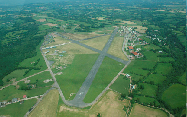
The twentieth century arrives by runway: RAF Dunkeswell and an American presence
If the abbey explains Dunkeswell’s medieval importance, the airfield explains its modern notoriety. During the Second World War, high ground and open space became strategic assets. Dunkeswell’s location—elevated, inland, and with room for long runways—made it suitable for an air base. RAF Dunkeswell, as it was known, formed part of the Allied air network at a time when the south-west of England was both a staging area and a defensive frontier.
The wartime history is bound up with the American presence in the region. Dunkeswell became associated with United States forces, including naval aviation operating from Britain. Coastal waters to the south and west were dangerous during the Battle of the Atlantic, and anti-submarine operations were a grim necessity. From bases like Dunkeswell, aircraft could patrol sea lanes, escort convoys, and hunt U-boats. For local people, this was a sudden encounter with global war: foreign accents in lanes, unfamiliar equipment on roads, and the knowledge that the parish’s skies were part of an international struggle.
The infrastructure of war reshaped the local geography. Runways and dispersal areas cut across fields; buildings, roads and security perimeters changed patterns of movement. Even after the war, traces remained in the land and in memory. Like many wartime airfields, Dunkeswell’s post-war story became one of adaptation: periods of different uses, changing ownership, and the difficult question of what to do with large military sites in rural settings.
Today, the airfield operates as a civilian facility. It supports general aviation and other flying activities, and it is known to many beyond Devon for parachuting. This brings a distinctive economic strand to a small parish: jobs linked to aviation services, maintenance, training and visiting activity. It also brings tensions typical of rural England, where the benefits of employment and local spending sit alongside concerns about noise, traffic, safety perceptions and the character of the countryside.
Understanding dunkeswell united kingdom in the present tense means understanding that the airfield is neither an anomaly nor a side note. It is a central part of why Dunkeswell’s name travels further than many villages of comparable size.
The parish today: settlement pattern, services and the texture of community
Dunkeswell is not a single, tightly bounded village in the way some places are. The parish includes scattered settlement, with the main village and the distinct locality around the abbey, as well as farms and small clusters of housing linked by lanes. This dispersed pattern is common in parts of Devon: communities formed around landholdings, chapels, crossroads and historic estates, rather than around one dominant high street.
Such places rely on a web of institutions rather than a single centre. Parish churches and chapels, halls used for meetings and events, sports and social clubs, and the informal networks that come with knowing neighbours by name all play a role. In a rural parish, community cohesion often depends on who has time and transport: the ability to collect children from activities, attend meetings, or check on an older resident in bad weather. Dunkeswell’s sense of community is therefore shaped as much by practical geography as by sentiment.
Like many rural areas, Dunkeswell has also experienced shifts in who lives there. Longstanding families remain, often connected to farming or local trades. At the same time, there are newer residents drawn by the landscape and relative quiet, some commuting to nearby towns or to Exeter. The result can be a mixture of expectations: differing views on development, on transport, on the airfield, and on how the parish should change.
What unites many people, regardless of background, is the everyday reality of distance. A trip to a supermarket, a secondary school, a hospital appointment or a rail station is not something done on foot. This shapes everything from household costs to social life, and it explains why local facilities—however modest—carry weight. In Dunkeswell, as across rural Devon, the question is not simply what amenities exist, but whether they are accessible without a car, and whether younger people can build a stable life in the area.
Farming and land use: the economics behind the pastoral view
To drive through Dunkeswell is to see fields, livestock and working yards. The countryside here is not ornamental. Much of it is actively managed, often by families who have worked the same holdings for generations, or by newer entrants operating under the pressures and opportunities of modern agriculture.
The dominant impression is grass: pasture for cattle and sheep, silage fields cut in season, and the hedged patchwork typical of the south-west. Farming in this landscape is shaped by weather, soil and slope. The higher ground can be wet underfoot for long periods, and the growing season can feel shorter than in lower Devon. That influences cropping choices and the balance between livestock and arable. Woodland also plays a role, from managed copses to larger blocks of forestry, and there is an ongoing conversation in the region about tree planting, biodiversity and carbon.
Economically, farming is a tightrope. Prices for milk and meat fluctuate; input costs—feed, fuel, fertiliser—can rise quickly; regulations and environmental schemes change. Many farms diversify to remain viable, taking on additional enterprises or contracting work. This is not romantic pastoralism but a business under constant recalibration.
These pressures intersect with environmental responsibilities. Hedgerows, watercourses and soil health are not abstract issues here; they have practical consequences. Erosion, nutrient runoff and flood risk are shaped by land management decisions. Conversely, careful stewardship can protect water quality and wildlife while keeping farms productive. In Dunkeswell, where the countryside is central to both identity and economy, debates about land use tend to be grounded in lived experience rather than ideology.
Nature and conservation: what the Blackdown Hills mean on the ground
The Blackdown Hills are valued for their landscapes and habitats, and that value is not merely aesthetic. The area supports a range of wildlife associated with mixed farming, hedgerows and woodland. Birds that depend on field margins, mammals using hedge corridors, bats foraging along treelines, and insects tied to unimproved grassland all depend on the way the land is managed.
Dunkeswell’s network of lanes can act as ecological conduits: sunken routes with banks, shade and damp microclimates. Old hedges can be species-rich, and small copses offer nesting and shelter. Streams and wet areas, where they remain intact, support amphibians and aquatic invertebrates and act as natural sponges during heavy rain. In a time of climate instability, such features matter.
Conservation in a working parish rarely looks like fence-post idealism. It is more often a set of negotiated choices: where to leave a margin unmown, when to lay a hedge rather than flail it, how to balance production with habitat. Schemes that pay for environmental outcomes can help, but they also bring paperwork and uncertainty. The success of conservation depends on continuity, and continuity is difficult when land economics are volatile.
There is also the heritage dimension. Landscapes like Dunkeswell’s are archives: not only of ecology but of human activity. Earthworks, old boundary banks, remnants of former field systems, and the subtle logic of settlement all tell a story. Even when buildings have gone, the land keeps a memory. For residents and visitors, recognising that the countryside is a record as well as a view can change how it is treated.
Getting in and out: roads, public transport and digital links
For many, the practical question behind “dunkeswell united kingdom” is simply: how do you reach it? Dunkeswell is served primarily by roads. It is not isolated in the dramatic sense, but it is reached via rural routes that can be narrow, winding and, in places, high-banked. The nearest larger towns—such as Honiton and Cullompton—provide access to wider road networks and services.
Rail connections are not in the parish itself, but nearby stations connect to Exeter and onward routes. That proximity matters for commuters and for anyone who cannot or does not wish to drive long distances. Yet the “last miles” remain a challenge. Rural bus services, where they exist, are often limited in frequency and vulnerable to funding changes. For young people, older residents, and those on lower incomes, this can be decisive. A village that seems perfectly connected on a county map can, in daily life, feel constrained by timetables and the cost of travel.
Digital connectivity has become another kind of transport. In recent years, expectations of broadband and mobile coverage have risen sharply, driven by remote work, online services and schooling needs. Rural areas have improved, but patchiness remains common. For a parish like Dunkeswell, reliable digital infrastructure is no luxury; it affects business viability, access to healthcare appointments, and whether a household can realistically work from home. It also shapes demographic change. Places with good connectivity can attract professionals who would otherwise be tied to cities, but that in turn can put pressure on local housing costs.
Housing and development: the difficult arithmetic of rural Devon
Housing is one of the most sensitive issues in rural parishes across the country, and Dunkeswell is no exception. The pressures are familiar: demand from people seeking rural homes, limited supply, and the challenge of providing housing that local wages can support. When new development is proposed, it often triggers arguments about scale, design, traffic and impact on landscape character. In a high-value environment like the Blackdown Hills, those concerns are intensified.
There is a further complication in Dunkeswell’s case: land use around the airfield and the implications of aviation activity for planning. Noise contours, safety considerations, and the physical footprint of airfield-related development can intersect with housing plans in ways that do not apply in a purely agricultural parish. The result is a planning landscape that requires careful judgement and, ideally, clear communication from authorities and stakeholders.
The underlying arithmetic is unforgiving. Without some level of new housing, communities can age and shrink, and services can become harder to sustain. With too much housing, or housing that does not match local needs, the parish can lose affordability and cohesion, and infrastructure can lag behind. The question, then, is not whether Dunkeswell should change—change is constant—but what kind of change strengthens the parish rather than weakening it.
In this sense, dunkeswell united kingdom is a case study in the broader national dilemma: how to keep rural England living, rather than turning it into a museum or an exclusive enclave, while still protecting the landscapes that make it worth living in.
Local identity: between abbey, airfield and everyday Devon
Places like Dunkeswell can be described in headlines—“historic abbey”, “wartime airfield”, “Blackdown Hills village”—but identity is built from smaller things. It is the feel of lanes at dusk, the way weather arrives fast on higher ground, the mixture of independence and interdependence that rural life produces.
The abbey contributes a sense of deep time. Even for those who are not particularly interested in religious history, the idea that a significant institution once stood here frames the parish as more than a collection of houses. It suggests continuity and loss, and it reminds people that Dunkeswell has been shaped by national events before.
The airfield contributes modern distinctiveness. Not many parishes can say that aircraft and parachutes are part of their regular horizon. For some residents, that is a point of pride or fascination; for others, it is a practical issue to be managed. Either way, it makes Dunkeswell recognisable beyond the county.
Then there is the ordinary Devon character: the resilience of farming families, the craft of local trades, the understated sociability of village events, the expectation that people will turn up when a neighbour needs help. Such traits do not belong to one place alone, but they take specific forms in each parish. Dunkeswell’s form is shaped by dispersion, by the physical presence of aviation infrastructure, and by the high-land landscape.
Education, healthcare and the essentials of rural living
For families considering a move, and for residents thinking about the parish’s future, practical services matter as much as heritage. Primary education may be available within reach, but secondary schooling typically involves travel to nearby towns. That can be manageable with good transport arrangements, but it adds complexity to daily life and can limit young people’s participation in after-school activities if travel is difficult.
Healthcare access follows a similar pattern. Local surgeries may be in nearby settlements, with hospitals further afield in Exeter or other larger centres. The move towards appointment systems that rely on digital access can benefit some households while disadvantaging others, especially where connectivity is unreliable or where residents are less comfortable online. For older people, distance and transport become critical factors, and community support networks often fill gaps that formal services cannot easily cover.
Emergency planning is another quiet reality. Rural lanes can be difficult in severe weather; fallen trees, flooding in low spots, and ice on exposed routes are not hypothetical. A community’s resilience often depends on shared knowledge—who has a tractor, who can check on the vulnerable, which routes remain passable. These are not the dramatic stories that dominate outside perceptions, but they are part of what it means to live in places like Dunkeswell.
Memory and meaning: why small places still matter
There is a temptation, when writing about a small parish, to either sentimentalise it or reduce it to data points. Dunkeswell resists both. It is not a relic, and it is not merely a dormitory for elsewhere. It contains active debates—about development, land use, aviation, and the environment—that mirror wider national questions. In that sense it is representative. Yet it is also specific, shaped by a combination of features that do not often coexist: a Cistercian legacy and a major wartime airfield; a protected landscape character and the modern demands of infrastructure; deep rural quiet and the sudden, unmistakable presence of flight.
This specificity is why searchers keep turning up “dunkeswell united kingdom”. They are looking for more than directions. They are looking for a coherent picture: how a place works, what holds it together, and what forces might pull it apart.
One of the most striking aspects of Dunkeswell is the way history remains legible without being curated. The airfield’s past is not behind glass; it is in the layout of the land and the continuing use of the site. The abbey’s significance is not confined to an entry in a guidebook; it is embedded in local geography and in the parish’s sense of itself. The landscape is not a backdrop; it is a working system that must be maintained and argued over.
Conclusion: Dunkeswell as a living parish, not a picturesque idea
Dunkeswell in the United Kingdom is, at heart, a place where the long view matters. Not the scenic view alone—though there are plenty of those—but the view through time. The parish has been shaped by institutions and events that arrived from outside: medieval monastic power, Tudor state reform, twentieth-century war and post-war aviation. It is now shaped by newer forces that are just as influential: housing pressure, changing agricultural economics, climate instability, and the uneven reach of transport and digital infrastructure.
What makes Dunkeswell compelling is that it shows how these forces settle into the grain of local life. They become questions discussed in parish meetings, compromises struck in planning decisions, changes made at the edge of fields, and routines adapted to match the realities of distance. The parish is neither frozen nor unrecognisable; it is negotiating its future with the tools and constraints it has.
To understand dunkeswell united kingdom is to understand that rural places are not empty spaces between towns. They are communities with histories that still shape their choices, landscapes that still demand skilled care, and identities that are not given once but made, again and again, in response to change.